A feature story from
|
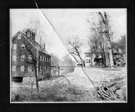
This photo of the original Spring Lake shows a mill and a house. Perhaps the lake was actually a mill pond. (Courtesy Dakota County Historical Society) Spring Lake — Legacy Lost and Found By Denny Caneff In my youth, Spring Lake was a mythical place, a watery Valhalla that conjured images of my grandfather communing with the woods and water and shooting anything that moved. I never knew this grandfather, Mathias N. (Matt) Gores, an avid hunter and outdoorsman. He died in 1952, two years before I was born. With my childhood love of tramping around in woods and fields and rivers, my mother told me I would have loved him. She saw that I shared his passion for the outdoors and solitude. I used to imagine going to Spring Lake with him to hunt — wherever Spring Lake was. I never went there in my childhood, and my mother couldn’t really describe its location. Spring Lake is the big lake backed up behind Lock and Dam 2, upstream of Hastings, Minn., my home town. But family lore had it that Spring Lake was a different place before the dam was finished in 1932 and flooded 10,000 acres of land upstream. My mother knew her father owned land in Spring Lake, but she didn’t know the details. Did he own the land before the dam went in? Was it flooded when the dam was built? Was he compensated for it? Did my grandfather Matt continue to hunt there after his land was underwater? My mother didn’t know, and none of the surviving Gores family had bothered to find out. But one cold January morning in 2016, standing at the windblown and driftwood laden shore of Spring Lake, I decided to figure out my family’s connection to Spring Lake and, perhaps, connect with the spirit of my Grandpa Matt.
First Visit THAT Spring Lake!? We drove west of Hastings, then down a bumpy, winding road in the dark, but suddenly the woods opened to a glistening expanse of water bathed in the industrial glow of 3M’s Chemolite plant and the refinery complex at Pine Bend, whose steam and smoke glowed orange in the night. We built a fire of driftwood, sipped beers and commiserated about suffering under our parents’ thumbs. The wind, water and dark worked their magic on me, and I thought about my grandfather Matt. Was this his Spring Lake? Did he come here to find respite from his own struggles with family and business? By the fire that night — Spring Lake’s waves lapping nearby — I made communion with Matt Gores. Dakota County Sleuthing I was burning with wonder. By that time, I had developed my own deep connection to the Mississippi, canoeing it from source to mouth in 1975 and, as a kid, spending many a summer day with a cousin wallowing in its murky waters below Lock and Dam 2. And now I discovered that my family owned islands in the Mississippi River and my mother was about to sell them. The county eventually paid my mother $23,000 for the islands, which she divided among her own kids and the children of her siblings, who were deceased. Why she was so conscientious about giving everyone a share of the proceeds became clear years later. My Spring Lake research in 2016 started with setting straight a possible myth I’d conjured over the decades: Was there a Spring Lake before the dam? I found a 1928 plat map of the area (the year before dam construction began) showing there was indeed a Spring Lake, maybe 80 acres. Spring Lake was a backwater lake whose northern shore was less than a mile from the Main Channel of the Mississippi. It was completely overwhelmed by the pool that Lock and Dam 2 created. Or maybe it wasn’t a natural lake after all. The only picture of the original Spring Lake that the Dakota County Historical Society could unearth, from 1907, shows a grist mill and a house, with a narrow stretch of water behind them. So perhaps “Spring Lake” was actually a mill pond created by a dam. By 1930, a few months after the stock market crash that triggered the Great Depression, the federal government announced the construction of the lock and dam that would inundate the original Spring Lake. In the boosterish tone of a Chamber of Commerce brochure, the St. Paul Dispatch reported that the “possibility that this lake will eventually become the greatest inland harbor and industrial center in the world is being predicted by individuals advocating the revival of river traffic on the Upper Mississippi.” The land belonging to those who fought the dam was condemned by the feds. Landowners were also offered “flowage easements,” wherein they held title to the land and were compensated by the federal government, but their land was largely or completely flooded. By 1932 the dam was completed, the original Spring Lake gone, and the new Spring Lake a massive slack-water pool.
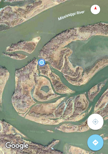
Buying a Watery Paradise My next communion with Grandpa Matt was not on the shore of Spring Lake, but in a Corps office gazing at an aerial map of the flooded land that he acquired after the dam was built. Seeing the aerial view of those parcels through my own river-rat eyes, I understood what he wanted from that land. It was — and in many ways still is — a surprisingly remote watery paradise. His first purchase, in 1934, was about 33 acres, about 80 percent of which was underwater, for which he paid about $2.30 an acre. That land was on the south shore of Spring Lake, adjacent to dry land that his brother Joe owned. I could imagine them cavorting on that land, shotguns cradled in their arms, their coon dogs howling at treed raccoons. Grandpa Matt then bought the islands in 1938 (about 21 acres) that my mother sold to Dakota County in 2002. He had paid “the sum of One dollar and other valuable considerations …” This looked like ideal duck hunting territory for my grandfather and his hunting buddies. Accessible only by boat, the islands were across the Main Channel from Lower Grey Cloud Island to the north with the quieter water of Spring Lake to the south. Today, as they did then, those islands define the right bank of the navigation channel as the river sweeps northeast toward Hastings and Lock and Dam 2. Area river rats may recognize the name “Gores” from a different river stretch: the Gores Wildlife Management Area (WMA), below Hastings, where the Vermillion River runs parallel to the Mississippi. I couldn’t find out whether this watery wildlife area was named for someone in my family, but it may have been named after my Grandpa Matt’s brother Joe Gores. I couldn’t verify it, but he may have sold some of his land to Minnesota for the Gores WMA.
Going Public When I reached Steve Sullivan, a planner for Dakota County Parks, he recalled my mother, in 2002, being adamant that the islands be sold in her lifetime to avoid the family conflict she apparently endured with her brother 17 years earlier. The happy ending to all this is that the 33-acres of shore land and the islands that my grandfather undoubtedly bought for his hunting retreat are now public land. Grandpa Matt’s shore land is part of the county’s Spring Lake Park Reserve. The Minnesota Department of Natural Resources owns the islands, accessible to the public both from the river channel and the county park. I finally got to "my islands" in early September of 2016. My daughter Amanda and I set sail from Dakota County Parks' archery park, on the south shore of Spring Lake. The islands that had been my granddad's were easy to find, using an iPhone’s Google map and maps indicating the Gores’ islands. We circumnavigated them, finding a massive cottonwood log to sun ourselves on while enjoying a beer. Though the channels around the islands are silting in, it felt like little else had changed since Matt Gores hunted here 65 years ago. We lifted our beers to offer him a toast. Denny Caneff was, until recently, the executive director of the River Alliance of Wisconsin. He lives in Madison, Wis. ©November 2016 Big River Magazine |
||