|
Big River Reader
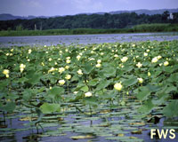
In late July and early August backwater lakes are full of floating white water lilies and bright yellow lotuses. Great blue herons, snowy egrets, kingfishers and ducks scold you for intruding into their quiet world.
Time stops as you rest your paddle across the gunwales, drift in the lazy current, empty your mind and let yourself be filled with the moment.
My favorite part of the river is the 60-mile stretch between La Crosse and Prairie du Chien, with only two dams and one city of more than a thousand people.
|
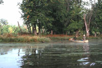
Canoeing the Big RiverBy Reggie McLeod Many great canoeing rivers flow into the Upper Mississippi. The Cannon, Chippewa, Zumbro, Whitewater, Trempealeau, Black, Root, Upper Iowa and Wisconsin Rivers all float canoe-loads of happy paddlers from early summer to late fall, but many end their canoe trips where I like to begin mine, in the Mississippi River. There are good reasons for canoeists to avoid the Mississippi -- barges, houseboats, giant cabin cruisers and water skiers -- but on weekdays during the fall you can have the whole river to yourself. And, when the light of the setting sun falls on the steep wooded bluffs, the autumn leaves light up in incandescent colors you'll never see anywhere else. Time stops as you rest your paddle across the gunwales, drift in the lazy current, empty your mind and let yourself be filled with the moment. Even in summer the Mississippi River is a great place to canoe. Much of the river consists of backwaters so shallow that you can touch bottom with your paddle. The big boats pretty much stay on the Main Channel, and even the bass boats get stuck in some of the backwaters where a canoe can go. Immediately below most of the dams are incredible mazes of backwaters. The Reno Bottoms, on the Minnesota side across from Genoa, Wisconson, has a reputation for being one of the most confusing labyrinths on the river. There are stories of people getting lost for days there. No map of the sluggish streams is much help. Many corridors end where a fallen tree blocks the way, or simply peter out in a patch of weeds. The current you were following to find your way might abruptly reverse direction. No, the Reno Bottoms, and backwaters like them, are no place for any boat that cannot be picked up and carried. However, canoeists who are feeling lost and desperate can catch sight of a bluff, then simply drag and carry their canoe through the muck and poison ivy until they get out. The U.S. Fish and Wildlife Service maintains well marked canoe trails on the river just below the dam at Trempealeau, Wisconsin, and at Wyalusing State Park, south of Prairie du Chien. The Indian Creek backwaters, upriver from Fountain City, Wisconsin, is also a popular canoeing spot. Many backwaters are easily accessible and fairly well mapped. In late July and early August backwater lakes are full of floating white water lilies and bright yellow lotuses that stand a couple of feet above the water, as if to upstage the lilies. Great blue herons, snowy egrets, kingfishers and ducks scold you for intruding into their quiet world. With a canoe you can explore fishing spots that are rarely visited or, perhaps, discover a heron rookery or a small clear lake that a larger boat could never get to. This makes a great day trip, but for a longer trip, week days in autumn are ideal. You can canoe for hours at a time without seeing any other humans; it's as if you have the river to yourself. Sandy islands, which are as busy and crowded as state parks on summer weekends, are deserted in the fall. When the sun goes down and the mosquitoes come out, it's cool enough to feel comfortable in a sweater or jacket. The water is usually low and the current sluggish. Massive flocks of coots and blackbirds join smaller flocks of ducks and geese on their fall trip downriver. The summer residents of the small river towns have packed up and left behind sleepy streets almost as quiet as the nearby backwaters. Barges do run in the fall, but on most of the river it is easy to keep a narrow island or two between you and the Main Channel. If you do get caught in open water when a barge or other large boat passes by, you might end up so jostled by the wake that you find yourself paddling the air. While it's a good idea to put some distance between your canoe and the larger boat, don't get too near the shore because the wake bouncing off the shore and wing dams will make you feel like you're in a crossfire. The Fish and Wildlife Service has fairly good maps of the Mississippi River, available for free at their offices and at some other locations along the river. Although helpful, there will be times when you'll find yourself in sections of the river that bear no resemblance to the map. The river is a living thing that changes from year to year. In addition, the water level fluctuates by several feet, and a change of several inches can make islands and passages appear or disappear. Because most of the river bottoms and islands from Lake Pepin to Rock Island, Illinois, are owned or managed by the Army Corps of Engineers or the Fish and Wildlife Service, they are open to camping and require no permit or fee, with the exception of a few campgrounds operated by the Corps. The sandy islands are nice, especially if you can find a sheltered spot. On many islands the main form of vegetation is poison ivy, which sometimes grows to the size of small trees, so it's a good idea to survey your campsite and carefully choose your firewood before it gets dark. Also, poison ivy's appearance varies from region to region, so look for those shiny leaves in groups of three. In some places hospitable islands are common, but in other sections of the river they are rare. Usually you see a lot of good campsites in the morning and early afternoon. In the late afternoon and early evening, when you are getting anxious to find a place to settle into, islands are hard to find or mucky and covered with a tangle of poison ivy. Unless you know of a good island that you can reach before nightfall, set up camp a little early if you find a good spot. My favorite part of the river is the 60-mile stretch between La Crosse and Prairie du Chien, with only two dams and one city of more than a thousand people -- Lansing, Iowa. The reason for the lack of cities is also the reason the river is so beautiful there, the 400-foot bluffs rise almost immediately from the river, leaving no room for settlements. In fact there is not even enough room for a road along a stretch of the Iowa shore below Lansing. The journey can be made in three or four days. At the end of the trip, at Prairie du Chien or Marquette or McGregor, Iowa, there are a number of fine state parks, motels and restaurants. September and early October are usually generous for providing warm sunny days. If you can find another paddler, a canoe and a few days for pleasure, and the weather is kind, you might get into the habit of saving some of those vacation days for a fall canoe trip on the Mississippi. © September 1994 |

 Wyalusing State Park