Mississippi River Note 3:
Vermillion River Bottoms - Warblers and
Wastewater
|
|
The Vermillion River cuts across the
flats of Dakota County to Hastings, Minn.,
where it tumbles over Vermillion Falls
into the Mississippi River Valley. From
there, one strand flows northeast to join
the larger river; another flows southeast,
paralleling the Mississippi for 17 miles
before joining it about one mile
downstream from Lock and Dam 3. Without
the Vermillion, Prairie Island wouldn't be
an island.
A 17-by-2.5-mile tract of floodplain
forest called the Vermillion River Bottoms
separates the two rivers. Here the
Vermillion meanders quietly past shallow
lakes and spring-fed marshes, through a
forest of silver maples and cottonwood,
peach-leafed willow and green ash.
Geologically, the Vermillion River Bottoms
is a remnant of the old braided-stream
river system that dominated the
Mississippi after the last glaciers
melted. When the new Lock and Dam 3
created Pool 3 in 1938, the Vermillion
River Bottoms kept much of its braided
quality.
"Vermillion" is the French translation
of a Sioux word for the bright red and
orange ocher found in nearby sandstone
formations. The river bottoms were popular
long before Europeans arrived; there are
31 known archeological sites in the
Mississippi Valley from the St. Croix to
the Cannon River, four of them within a
half-mile of the outlet of Goose Lake,
near Prairie Island.
Traveling by water here offers the
chance to see herons rise out of the
shallows and butter-yellow prothonotary
warblers dart across the channel. This
floodplain forest is home to kingfishers,
flycatchers, owls and many species of
birds rarely found in more accessible
places.
One rare bird that lives here is the
cerulean warbler. The male of the species
sports azure blue on its back and wings,
and snow-white underneath; the female
wears a less vivid gray-blue plumage. They
winter in the mountain forests of
Venezuela and Peru, and return in the
spring by way of the Mississippi River
Flyway. They are among the first birds to
arrive, court and build nests in the high
treetops of the forest in April. These
birds are rarely seen because they are so
tiny and elusive, and because their
numbers have diminished by 2.6 percent per
year from 1966 to 1993, according to the
Robbins-Sauer study of Breeding Bird
Surveys.
"That means that there were roughly
twice as many cerulean warblers just 25
years ago as there are today," said Rich
Swanson, a birder and writer. Swanson
spends a lot of time in Mississippi River
floodplain forests, keeping tabs on
ceruleans and other secretive species. He
believes their decline may be linked to
the decline of floodplain forests.
In a 1990 study, the Minnesota
Department of Natural Resources (DNR) and
the Army Corps of Engineers both found
that the Vermillion River Bottoms were
ailing. Some places that used to hold vast
beds of freshwater mussels no longer
contained any live mussels, just shells.
Rough fish were replacing game fish and
diversity was declining. Marshes were
filling in. The water was turbid with silt
and algae. Aquatic grasses and tubers were
dying back, so fewer waterfowl visited
there. Populations of muskrats, beaver and
other fur-bearers were down.
The report attributed the decline to a
loss of aquatic plants caused by the
perpetually high water levels of the
dammed Mississippi River, which backs up
into the Vermillion River Bottoms.
Sediment that doesn't dry out once in a
while is easily stirred up by wind or
waves. Turbid waters block the light and
destroy the aquatic plants that feed and
shelter fish, birds and mammals. The Corps
and DNR proposed control structures and
pumping stations to draw down the water
every ten years, allowing the mud to dry
out. But the project failed to win
approval, and the Vermillion River Bottoms
has continued to decline.
"I don't think we would consider that
kind of water control project, now that
the Corps is seriously studying water
drawdowns pool-wide. The whole idea was to
shift to rooted plants. It was a desperate
attempt to knock the river into a steady
state," said Mike Davis, DNR biologist in
Lake City, Minn. "In the meantime the
Vermillion has become an increasingly
algae-driven system. We've seen continued
degradation." That means more mud and
algae; shallower lakes, fewer fish, plants
and waterfowl; and less diversity.
|
Phosphorus from Upstream
|
|
Dense green mats of algae &emdash;
called nuisance blooms &emdash; frequently
cover the shallow lakes in summer. But too
much water is not the only problem. Since
1979, the Vermillion River Bottoms have
received lots of phosphorus, which
stimulates algae, which further blocks the
light. The source of the phosphorus is the
Empire Wastewater Treatment Plant in
Farmington, Minn., upstream from Hastings.
Long-term phosphorus levels in the
river just downstream from the Empire
Plant average 0.91 milligrams per liter
(mg/liter). By comparison, the Mississippi
River, which is notoriously high in
phosphorus downstream from the Pig's Eye
Wastewater Treatment Plant, averages 0.24
mg/liter.
The Empire Plant is a modern,
efficient-looking complex of buildings
that handles the waste of the growing
communities of Lakeville, Farmington and
Apple Valley. The plant was built in 1979
to handle three million gallons of
wastewater per day and has expanded
several times, the most recent in 1997,
bringing the plant to a
12&endash;million-gallon-per-day capacity.
Jim Sipe, manager of the Empire Plant,
pointed out that effluent from the plant
contributes one-quarter to one-third to
the volume of the river. "In the time I've
been here the effluent flow has increased
quite a bit, but so has the flow in the
river itself. A lot of that is because
there's just more run-off from roads and
parking lots, because there is a lot more
development in the area than there used to
be."
The effluent that flows into the
Vermillion River looks clear. Indeed,
Metropolitan Council Environmental
Services (MCES) claims it is the cleanest
effluent in its whole system, which
processes the wastewater of 2.2 million
residents in the Twin Cities area.
Unfortunately for the Vermillion River
Bottoms, the Empire Plant does nothing to
remove phosphorus.
The MCES plans to reduce every plant's
phosphorus release to one mg/liter by the
year 2015. Empire's effluent today
averages more than four mg/liter. The MCES
will add biological phosphorus removal
capabilities as plants are expanded.
But by the year 2050, MCES projects
that the Empire Plant will be discharging
more than 23 million gallons of water per
day into the Vermillion &emdash; a 250
percent increase over 1997. How will the
Vermillion River Bottoms handle that? If
phosphorus levels dropped again, would the
aquatic vegetation return? Questions are
more plentiful than answers.
The fact that this meandering, slow,
bottomland river is separate from the
Mississippi gives some biologists hope
that habitat and ecosystems here could be
restored more easily than on the
Mississippi itself. Some people dream of
building a bicycle trail on an abandoned
railroad bed that parallels the river.
This trail would connect with the Cannon
River Bike Trail at Red Wing and bring
people down for a glimpse of an ancient,
still-braided river and maybe a bright
warbler or two.
|
|
Vermillion Falls
In 1853 the Vermillion River powered
the first flour mill in Minnesota, built
by Harrison Graham, who milled a new kind
of flour &emdash; graham flour, made from
winter wheat.
The Peavey Company now owns the mill
site, and the waterfall is in a city park,
just off Highway 61 in Hastings, across
the river from the Peavey grain elevators.
|
Things to Do &
See
|
|
Canoe Trail
Take Highway 54 south from
Hastings and across the bridge on
the outskirts of town. Continue
about four miles to the boat
landing. From there you can go
upstream through the Ravenna
Wildlife
|
|
Management Area, straight across to the
Mississippi River by way of Truedale
Slough, or downstream toward Clear Lake,
Wood Slough and Rattling Springs.
The Minnesota DNR publishes a canoe
route map for the stretch of the
Mississippi from Red Wing to Hastings,
which marks the Vermillion as an
alternative route.
|
|
|

|
|
|
|
|
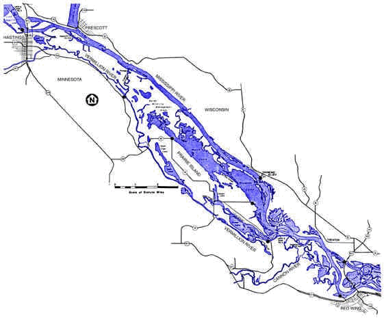
This map shows the Vermillion River Bottoms,
between the Vermillion River and the Mississippi.
At the top of the map a channel connects the
Vermillion to the Mississippi, just downriver from
Hastings. The St. Croix River joins the Mississippi
at Prescott.
The Vermillion flows into the Mississippi at
Diamond Island about three miles upstream from Red
Wing.
Boat landings are marked with black dots.
|
For Your Information
The map on the opposite page used information
from the Mississippi River Canoe Route, Hastings to
Red Wing, published by the Minnesota DNR.
Minnesota Geographic Names, Their Origin and
Historic Significance, Minnesota Historical
Society, 1920, provided information about the
Vermillion River's name.
The Minnesota County Biological Survey Map 16
(Dakota County), 1997, and Map 9 (Goodhue County),
1995, Minnesota DNR, show habitat types in the
Vermillion River Bottoms.
The Minnesota DNR and the US Army Corps of
Engineers published several reports on the proposed
Goose Lake/Vermillion River Bottoms Habitat
Rehabilitation and Enhancement Project.
This and other River Notes are available on the
Big River World Wide Web site (www.big-river.com)
or from the Minnesota-Wisconsin Boundary Area
Commission, 619 Second St., Hudson, WI 54016-1576;
(612) 436-7131 or (715) 386-9444.
Mississippi River Notes are created by
Riverwise, Inc., (P.O. Box 204, Winona, MN 55987)
for the Minnesota-Wisconsin Boundary Area
Commission, with support from the McKnight
Foundation.
This River Note is in the public domain. You may
copy and distribute it without permission.
February 1998
|
|